CURRENT ACTIVE HURRICANES

WESTERN ATLANTIC HURRICANE IDA

EASTERN PACIFIC


Keep Updated on the Latest and Hottest News with HTBW

Keep you and your children safe. Find the latest Product Recalls here.
Your Ad Here

Monday, August 31, 2009

HURRICANE JIMENA sparks HURRICANE WATCH IN MEXICO

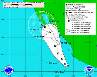
HURRICANE JIMENA PROJECTED PATH


HURRICANE WARNINGS ISSUED FOR SOUTHERN BAJA CALIFORNIA...

AT 8 AM PDT...1500 UTC...THE GOVERNMENT OF MEXICO HAS CHANGED THE
HURRICANE WATCH TO A HURRICANE WARNING FOR THE SOUTHERN PORTION OF
THE BAJA CALIFORNIA PENINSULA FROM BAHIA MAGDALENA SOUTHWARD ON THE
WEST COAST...AND FROM SAN EVARISTO SOUTHWARD ON THE EAST COAST...
INCLUDING CABO SAN LUCAS. A HURRICANE WARNING MEANS THAT HURRICANE
CONDITIONS ARE EXPECTED SOMEWHERE WITHIN THE WARNING AREA WITHIN 24
HOURS. PREPARATIONS TO PROTECT LIFE AND PROPERTY SHOULD BE RUSHED
TO COMPLETION.


AT 8 AM PDT...1500 UTC...THE GOVERNMENT OF MEXICO HAS ISSUED A
HURRICANE WATCH FOR THE BAJA CALIFORNIA PENINSULA NORTH OF BAHIA
MAGDALENA ON THE WEST COAST TO PUNTA ABREOJOS AND NORTH OF SAN
EVARISTO TO MULEGE ON THE EAST COAST. A HURRICANE WATCH MEANS THAT
HURRICANE CONDITIONS ARE POSSIBLE WITHIN THE WATCH AREA...GENERALLY
WITHIN 36 HOURS.

INTERESTS ELSEWHERE IN THE CENTRAL BAJA CALIFORNIA PENINSULA AND IN
WESTERN MAINLAND MEXICO SHOULD MONITOR THE PROGRESS OF JIMENA.

FOR STORM INFORMATION SPECIFIC TO YOUR AREA...PLEASE MONITOR
PRODUCTS ISSUED BY YOUR NATIONAL METEOROLOGICAL SERVICE.


AT 800 AM PDT...1500 UTC...THE CENTER OF HURRICANE JIMENA WAS
LOCATED NEAR LATITUDE 18.0 NORTH...LONGITUDE 108.3 WEST OR ABOUT 355
MILES...570 KM...SOUTH-SOUTHEAST OF CABO SAN LUCAS MEXICO.

JIMENA IS MOVING TOWARD THE NORTHWEST NEAR 8 MPH...13 KM/HR...AND A
TURN TOWARD THE NORTH-NORTHWEST WITH A GRADUAL INCREASE IN FORWARD
SPEED IS EXPECTED OVER THE NEXT DAY OR SO. ON THE FORECAST
TRACK...JIMENA WILL BE APPROACHING THE SOUTHERN PORTION OF THE BAJA
CALIFORNIA PENINSULA ON TUESDAY.

MAXIMUM SUSTAINED WINDS ARE NEAR 145 MPH...230 KM/HR...WITH HIGHER
GUSTS. JIMENA IS AN EXTREMELY DANGEROUS CATEGORY FOUR HURRICANE ON
THE SAFFIR-SIMPSON SCALE. SOME FLUCTUATIONS IN INTENSITY ARE
POSSIBLE DURING THE NEXT DAY OR TWO. AN AIR FORCE RESERVE
HURRICANE HUNTER AIRCRAFT IS SCHEDULED TO INVESTIGATE JIMENA LATER
TODAY.

HURRICANE FORCE WINDS EXTEND OUTWARD UP TO 30 MILES...45 KM...FROM
THE CENTER...AND TROPICAL STORM FORCE WINDS EXTEND OUTWARD UP TO 80
MILES...130 KM.


ESTIMATED MINIMUM CENTRAL PRESSURE IS 940 MB...27.76 INCHES.

JIMENA IS EXPECTED TO PRODUCE TOTAL RAIN ACCUMULATIONS OF 5 TO 10
INCHES OVER THE SOUTHERN HALF OF THE BAJA CALIFORNIA PENINSULA AND
PORTIONS OF WESTERN MEXICO DURING THE NEXT 2 DAYS...WITH POSSIBLE
ISOLATED MAXIMUM AMOUNTS OF 15 INCHES.

A STORM SURGE ALONG WITH LARGE AND DANGEROUS BATTERING WAVES WILL
PRODUCE SIGNIFICANT COASTAL FLOODING ALONG THE BAJA CALIFORNIA
PENINSULA.

...SUMMARY OF 800 AM PDT INFORMATION...
LOCATION...18.0N 108.3W
MAXIMUM SUSTAINED WINDS...145 MPH
PRESENT MOVEMENT...NORTHWEST OR 315 DEGREES AT 8 MPH
MINIMUM CENTRAL PRESSURE...940 MB

Sunday, August 30, 2009

HURRICANE JIMENA UPDATE STRONGER WILL HANG AROUND LONGER

Not much has changed in HURRICANE JIMENA over the last day except location and a 5MPH increase in wind speed. HURRICANE JIMENA is still a very dangerous HURRICANE with sustained wind speeds at 140 MPH or 220 KPH with higher gusts.


HURRICANE JIMENA is moving WNW at approx 8 MPH or 13 KPH. The slower progression of HURRICANE JIMENA, when compared to the speeds of HURRICANE DANNY or BILL, make HURRICANE JIMENA more dangerous when she hits an area as HURRICANE force winds will hang around for longer.

HURRICANE JIMENA is expected to make a shift to the Nortwest then North North West over the next 48 hours. This PROJECTED PATH will bring HURRICANE JIMENA right up the Baja Coast into the southern tip of the California Baja Peninsula.


HURRICANE JIMENA and TS KEVIN UPDATE

The Western Atlantic and Hurricane Danny have calmed down abit and the Eastern Pacific is once again being ravaged by storms. Hurricane Jimena popped up over the last few days and is now threatening to hit the Baja Coast. This will be the first direct hit Hurricane for the Eastern Pacific, there were a few close

HURRICANE JIMENA SATELLITE IMAGE


calls, however those Hurricanes did manage to calm down a little before they got close to land.


HURRICANE JIMENA


At the present time, those in Western Mainland Mexico and the Southern California Baja Peninsula are being warned to keep an eye on HURRICANE JIMENA.

HURRICANE JIMENA is currently a CATEGORY 4 HURRICANE producing sustained winds of 135 MPH or 215 KM/HR with even higher wind gusts. The NOAA HURRICANE TRACKER WEATHER OFFICE is expecting HURRICANE JIMENA to strengthen substantially over the next 48 hours as she heads towards the southern Baja.

HURRICANE JIMENA PROJECTED PATH


HURRICANE force winds are extending 25 MILES or 35 KM from the eye of HURRICANE JIMENA and Tropical Storm Force winds up to 70 Miles or 110 KM from the eye. Although HURRICANE JIMENA seems like a small HURRICANE in width, she is still very dangerous, as you can see in the HURRICANE JIMENA PROJECTED PATH, the EYE OF HURRICANE JIMENA is expected to head right over the Southern Baja by Tuesday.


HURRICANE JIMENA will likely produce large swells and a substantial amount of damage to the southern California Baja. Stay tuned to Eye On the HurrIcane - Hurricane Tracker for LIVE WEB CAMERA's of the CALIfRONIA BAJA as HURRICANE JIMENA heads towards land.

TROPICAL STORM KEVIN


TS KEVIN is another active Eastern Pacific storm, however, unlike HURRICANE JIMENA, TS KEVIN is not expected to hit land and NOAA HURRICANE TRACKER officials are predicting TROPICAL STORM KEVIN will disipate over the water. TROPICAL STORM KEVIN is moving quite slow and is not expected to reach HURRICANE status.


Thursday, August 27, 2009

TROPICAL STORM / HURRICANE DANNY UPDATE

With Tropical Storm TS Ignacio calming down further in the Pacific Ocean, we now have Tropical Storm TS Danny rapidly approaching Category 1 Hurricane Status. The eye of Hurricane Danny has reformed slightly farther north.


Maximum sustained winds being produced by TS Danny are currently at 60 MPH or 95 KPH with gusts approaching those of Hurricane status (over 75 MPH for Category 1). The NOAA Hurricane tracker office is warning those in The Caolina's north to New England should monitor TS Danny as he may very well beccome Hurricane Danny quite shortly.

Tropical Storm Danny is currently 370 Miles or 590 KM ENE of Nassau and approximately 575 Miles or 925 KM SSE of Cape Hatteras North Carolina. With a travelling speed of about 10 MPH with a Northwest heading, Tropical Storm Danny should be effecting any of those area's sometime today. NOAA Weather officials are predicting a Northward shift in direction for TS or Hurricane Danny later today. This shift in direction is what would bring TS or Hurricane Danny towards the Carolina's.


Tropical Storm Danny is expected to become Hurricane Danny by 2AM on Saturday morning when he is of the coast of the Carolina's. The eye of Hurricane Danny is expected to hit land on the South west Coast of Nova Scotia by 2AM Sunday morning. This will be the second Hurricane hit on the Atlantic Province of Nova Scotia this week.


A few days ago, Police were stationed by Peggy's Cove in attempts to ward off hurricane watchers who wanted to catch a glimpse of Hurricane Bill and the massive swells he was producing. EyeOnTheHurrIcane - Hurricane Tracker has several live webcams from Nova Scotia posted, including one of Peggy's Cove. Wherever Hurricane Danny hits land, and where available, you can be sure EyeOnTheHurricane - Hurricane Tracker will have live webcam feeds of Hurricane Danny.

Tuesday, August 25, 2009

HURRICANE UPDATE - DANNY, IGNACIO and HILDA

TROPICAL STORM IGNACIO ADVISORY NUMBER 3
NWS TPC/NATIONAL HURRICANE CENTER MIAMI FL EP122009
200 AM PDT TUE AUG 25 2009

...IGNACIO MOVING TOWARD THE WEST-NORTHWEST WITH LITTLE CHANGE IN
STRENGTH....

AT 200 AM PDT...0900 UTC...THE CENTER OF TROPICAL STORM IGNACIO WAS
LOCATED NEAR LATITUDE 18.1 NORTH...LONGITUDE 118.5 WEST OR ABOUT 650
MILES...1040 KM...WEST-SOUTHWEST OF THE SOUTHERN TIP OF BAJA
CALIFORNIA.


IGNACIO IS MOVING TOWARD THE WEST-NORTHWEST NEAR 12 MPH...19 KM/HR.
A TRACK BETWEEN THE WEST-NORTHWEST AND NORTHWEST IS EXPECTED FOR
THE NEXT 24 TO 48 HOURS.

MAXIMUM SUSTAINED WINDS ARE NEAR 40 MPH...65 KM/HR...WITH HIGHER
GUSTS. SOME STRENGTHENING IS FORECAST DURING THE NEXT 24 TO 36
HOURS BEFORE IGNACIO REACHES COOLER WATERS.

TROPICAL STORM FORCE WINDS EXTEND OUTWARD UP TO 50 MILES...85 KM
FROM THE CENTER.

ESTIMATED MINIMUM CENTRAL PRESSURE IS 1004 MB...29.65 INCHES.

...SUMMARY OF 200 AM PDT INFORMATION...
LOCATION...18.1N 118.5W
MAXIMUM SUSTAINED WINDS...40 MPH
PRESENT MOVEMENT...WEST-NORTHWEST OR 295 DEGREES AT 12 MPH
MINIMUM CENTRAL PRESSURE...1004 MB


1. The Central Pacific Hurricane Center in Honolulu is issuing advisories on tropical storm Hilda, located about 540 miles southeast of Hilo, Hawaii. Hilda is moving westward around 9 mph. Public advisories on Hilda are being issued under WMO header WTPA25 PHFO and under AWIPS header HFOTCPCP5.


2. Poorly organized thunderstorms continue within a nearly stationary, west-southwest to east-northeast oriented surface trough located over 1000 miles southwest of Honolulu. Development within this trough is unlikely over the next 48 hours.


A LARGE AREA OF CLOUDINESS AND THUNDERSTORMS CENTERED ABOUT 300 MILES NORTHEAST OF SAN JUAN PUERTO RICO IS ASSOCIATED WITH A TROPICAL WAVE INTERACTING WITH AN UPPER-LEVEL LOW. EARLY MORNING VISIBLE SATELLITE IMAGES SUGGEST THAT THE WAVE HAS BECOME A LITTLE BETTER ORGANIZED. UPPER-LEVEL WINDS ARE FORECAST TO BECOME MORE CONDUCIVE FOR DEVELOPMENT DURING THE NEXT DAY OR SO AS THE SYSTEM MOVES WEST-NORTHWESTWARD AROUND 20 MPH. THERE IS A HIGH CHANCE...GREATER THAN 50 PERCENT...OF THIS SYSTEM BECOMING A TROPICAL CYCLONE DURING THE NEXT 48 HOURS. A RECONNAISSANCE AIRCRAFT IS SCHEDULED TO INVESTIGATE THE AREA THIS AFTERNOON. INTERESTS IN THE BAHAMAS AND THE TURKS AND CAICOS ISLANDS SHOULD MONITOR THE PROGRESS OF THIS SYSTEM. AS IT COULD BECOME TROPICAL STORM DANNY OR HURRICANE DANNY


Sunday, August 23, 2009

HURRICANE BILL NOVA SCOTIA WEBCAMS and UPDATE


HURRICANE BILL is headed for a direct hit on Nova Scotia Canada. At the current time, HURRICANE BILL is hovering 95 Miles or 150 KM off Halifax Harbour. With Hurricane force winds extending 85 Miles or 140 KM from the eye of HURRICANE BILL 2009, it is not hard to see how Halifax and area's north of the provincial capital will be effected.


As mentioned, Hurricane Force winds of 85 MPH or 140 KPH are extending 85 Miles from the eye of HURRICANE BILL as it storms off the coast of Nova Scotia. HURRICANE BILL is currently heading North East at 33MPH or 54 KPH. HURRICANE BILL is currenty a Category 1 HURRICANE.

The Environment Canada Hurricane centre is predicting waves up to 8 meters will hit the eastern Nova Scotia seaboard today decreasing to 3 Meters after midnight.

The projected path of Hurricane Bill also brings it towards Newfoundland. Environment Canada Hurricane centre is predicting HURRICANE BILL wil further diminish by the time it hits Newfoundland.

The confederation bridge, the longest bridge in North America, which connects New Brunswick and Prince Edward Island will most likely be closed due to severe wind conditions.


Below are some LIVE HURRICANE BILL WEB CAMERA's from NOVA SCOTIA CANADA. These LIVE WEB CAMS are LIVE FOOTAGE OF HURRICANE BILL as it hits NOVA SCOTIA. To see updated images, simply press REFRESH on your browser. This will load the newest NOVA SCOTIA HURRICANE BILL WEB CAMERA LIVE FOOTAGE


Saturday, August 22, 2009

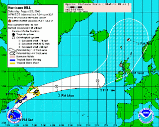
HURRICANE BILL Will cause substantial Damage

HURRICANE BILL INTERMEDIATE ADVISORY NUMBER 30A
NWS TPC/NATIONAL HURRICANE CENTER MIAMI FL AL032009
800 PM AST SAT AUG 22 2009

...BILL MOVING NORTHWARD...EXPECTED TO PASS OFFSHORE OF NEW ENGLAND
TONIGHT...

A TROPICAL STORM WARNING REMAINS IN EFFECT FOR THE EAST COAST OF
NOVA SCOTIA FROM CHARLESVILLE TO POINT ACONI. A HURRICANE WATCH
REMAINS IN EFFECT FOR THE EAST COAST OF NOVA SCOTIA FROM ECUM SECUM
TO POINT ACONI.

A TROPICAL STORM WARNING REMAINS IN EFFECT FOR THE COAST OF
MASSACHUSETTS FROM WOODS HOLE TO SAGAMORE BEACH...INCLUDING THE
ISLANDS OF MARTHAS VINEYARD AND NANTUCKET.


A TROPICAL STORM WATCH REMAINS IN EFFECT FOR THE NORTHERN COAST OF
NOVA SCOTIA FROM NORTH OF POINT ACONI WESTWARD TO TIDNISH...FOR THE
WESTERN COAST OF NOVA SCOTIA FROM FORT LAWRENCE TO CHARLESVILLE...
AND FOR PRINCE EDWARD ISLAND FROM VICTORIA IN QUEEN COUNTY
NORTHWARD TO LOWER DARNLEY IN PRINCE COUNTY. A TROPICAL STORM WATCH
IS ALSO IN EFFECT FROM PARSONS POND AROUND THE WESTERN...
SOUTHERN...AND EASTERN COASTS OF NEWFOUNDLAND TO HARBOUR DEEP.

INTERESTS ELSEWHERE ALONG THE COAST OF NEW ENGLAND AND IN THE
CANADIAN MARITIMES SHOULD MONITOR THE PROGRESS OF BILL.

FOR STORM INFORMATION SPECIFIC TO YOUR AREA IN THE UNITED
STATES...INCLUDING POSSIBLE INLAND WATCHES AND WARNINGS...PLEASE
MONITOR PRODUCTS ISSUED BY YOUR LOCAL NATIONAL WEATHER SERVICE
FORECAST OFFICE. FOR STORM INFORMATION SPECIFIC TO YOUR AREA
OUTSIDE OF THE UNITED STATES...PLEASE MONITOR PRODUCTS ISSUED BY
YOUR NATIONAL METEOROLOGICAL SERVICE.


AT 800 PM AST...0000 UTC...THE CENTER OF HURRICANE BILL WAS LOCATED
NEAR LATITUDE 37.8 NORTH...LONGITUDE 68.3 WEST OR ABOUT 255
MILES...415 KM...SOUTH-SOUTHEAST OF NANTUCKET MASSACHUSETTS AND
ABOUT 550 MILES...880 KM...SOUTH-SOUTHWEST OF HALIFAX NOVA SCOTIA.

BILL IS MOVING TOWARD THE NORTH NEAR 24 MPH...39 KM/HR. THIS MOTION
IS EXPECTED TO CONTINUE TONIGHT WITH A GRADUAL TURN TO THE
NORTH-NORTHEAST ON SUNDAY. ON THE FORECAST TRACK...THE CORE OF
HURRICANE BILL SHOULD PASS OFFSHORE OF THE COAST OF NEW ENGLAND
TONIGHT...MOVE OVER OR NEAR NOVA SCOTIA ON SUNDAY...AND BE NEAR
NEWFOUNDLAND SUNDAY NIGHT.

MAXIMUM SUSTAINED WINDS ARE NEAR 85 MPH...140 KM/HR...WITH HIGHER
GUSTS. BILL IS A CATEGORY ONE HURRICANE ON THE SAFFIR-SIMPSON
SCALE. WEAKENING IS EXPECTED TO BEGIN ON SUNDAY AS BILL MOVES OVER
COOLER WATERS.

HURRICANE FORCE WINDS EXTEND OUTWARD UP TO 85 MILES...140 KM...FROM
THE CENTER...AND TROPICAL STORM FORCE WINDS EXTEND OUTWARD UP TO
275 MILES...445 KM.

THE ESTIMATED MINIMUM CENTRAL PRESSURE IS 961 MB...28.38 INCHES.


TOTAL RAIN ACCUMULATIONS OF 3 TO 5 INCHES WITH ISOLATED MAXIMUM
AMOUNTS OF 7 INCHES ARE EXPECTED NEAR THE TRACK OF BILL ACROSS NOVA
SCOTIA...PRINCE EDWARD ISLAND AND NEWFOUNDLAND. 1 TO 2 INCHES OF
RAIN ARE EXPECTED OVER NANTUCKET ISLAND...WITH AROUND 1 INCH
EXPECTED OVER OUTER CAPE COD AND MARTHAS VINEYARD.

LARGE SWELLS GENERATED BY HURRICANE BILL WILL CONTINUE TO AFFECT
MUCH OF THE U.S. EAST COAST AND SPREAD INTO THE ATLANTIC MARITIMES
OF CANADA TONIGHT AND SUNDAY. THESE SWELLS WILL LIKELY CAUSE
EXTREMELY DANGEROUS SURF AND LIFE-THREATENING RIP CURRENTS. SWELLS
FROM BILL ARE STILL AFFECTING THE BAHAMAS AND BERMUDA BUT SHOULD
GRADUALLY DIMINISH TONIGHT.

...SUMMARY OF 800 PM AST INFORMATION...
LOCATION...37.8N 68.3W
MAXIMUM SUSTAINED WINDS...85 MPH
PRESENT MOVEMENT...NORTH OR 360 DEGREES AT 24 MPH
MINIMUM CENTRAL PRESSURE...961 MB

THE NEXT ADVISORY WILL BE ISSUED BY THE NATIONAL HURRICANE CENTER AT
1100 PM AST.

$$
FORECASTER BRENNAN

TROPICAL STORM HILDA

TROPICAL STORM HILDA ADVISORY NUMBER 2
NWS TPC/NATIONAL HURRICANE CENTER MIAMI FL EP112009
200 PM PDT SAT AUG 22 2009

...NEW TROPICAL STORM FORMS IN THE FAR WESTERN PORTION OF THE
EASTERN PACIFIC BASIN...

AT 200 PM PDT...2100 UTC...THE CENTER OF TROPICAL STORM HILDA WAS
LOCATED NEAR LATITUDE 13.6 NORTH...LONGITUDE 137.7 WEST OR ABOUT
1930 MILES...3105 KM...WEST-SOUTHWEST OF THE SOUTHERN TIP OF BAJA
CALIFORNIA AND ABOUT 1225 MILES...1970 KM...EAST-SOUTHEAST OF HILO
HAWAII.

HILDA IS MOVING TOWARD THE WEST NEAR 10 MPH...17 KM/HR...AND THIS
MOTION IS EXPECTED TO CONTINUE FOR THE NEXT 24 TO 48 HOURS.

MAXIMUM SUSTAINED WINDS HAVE INCREASED TO NEAR 40 MPH...65
KM/HR...WITH HIGHER GUSTS. LITTLE CHANGE IN STRENGTH IS EXPECTED
DURING THE NEXT DAY OR TWO.

TROPICAL STORM FORCE WINDS EXTEND OUTWARD UP TO 35 MILES...55 KM
FROM THE CENTER.

ESTIMATED MINIMUM CENTRAL PRESSURE IS 1006 MB...29.71 INCHES.

...SUMMARY OF 200 PM PDT INFORMATION...
LOCATION...13.6N 137.7W
MAXIMUM SUSTAINED WINDS...40 MPH
PRESENT MOVEMENT...WEST OR 275 DEGREES AT 10 MPH
MINIMUM CENTRAL PRESSURE...1006 MB

THE NEXT ADVISORY WILL BE ISSUED BY THE NATIONAL HURRICANE CENTER AT
800 PM PDT.

$$
FORECASTER KIMBERLAIN/BRENNAN

HURRICANE BILL - NOVA SCOTIA HURRICANE WARNINGS

As HURRICANE BILL is moving north, Environment Canada has now issued a TROPICAL STORM WARNING for NOVA SCOTIA FROM CHARLESVILLE IN SHELBURNE COUNTY
EASTWARD TO ECUM SECUM IN HALIFAX COUNTY also FROM NORTH OF POINT ACONI WESTWARD TO TIDNISH AND FROM VICTORIA IN QUEEN COUNTY NORTHWARD TO LOWER DARNLEY IN PRINCE COUNTY PRINCE EDWARD ISLAND and FROM PARSONS POND AROUND THE SOUTHWESTERN PORTION OF NEWFOUNDLAND TO ARNOLDS COVE

A HURRICANE WATCH has been issued in Nova Scotia FROM JUST EAST OF ECUM SECUM TO POINT ACONI.


HURRICANE BILL is still a Category 2 HURRICANE with sustained wind speeds of 100 MPH or 160KPH. HURRICANE FORCE winds are being recorded 85 Miles or 140 KM from the Eye of HURRICANE BILL.

Large swells generated by HURRICANE BILL are still hitting the Bahamas, Bermuda and approaching the SE Coast of the United States. Points further north up into the Atlantic Maritime Provinces of Canada will start to see large swells from HURRICANE BILL later today and through the weekend. Weather officials are continuing to warn individuals to stay out of the water as the swells from HURRICANE BILL will likely cause life threatening rip currents


There is no further major development in the possibility of the weather system currently following HURRICANE BILL. There has been some growth and it may in fact become Tropical Storm Danny.

Meanwhile, the weather system in the Eastern Pacific is getting a little stronger and is one step closer to becoming TROPICAL STORM HILDA which may lead to HURRICANE HILDA.


Stay tuned to the HTBW HURRICANE TRACKER for constant updates as HURRICANE BILL heads up the eastern seaboard. As webcamer's are available, HTBW HURRICANE TRACKER will post a number of HURRICANE WEB CAMERA's from the effected area's

Here is a LIVE WEBCAMERA from the NOVA SCOTIA COAST Click REFRESh to get an updated image


Here is a LIVE WEB CAM in NEWFOUNDLAND


Friday, August 21, 2009

HURRICANE BILL Moving towards New York, Nova Scotia and Newfoundland

HURRICANE BILL is making his way north up the New England Coast towards Nova Scotia and the Maritime provinces of Canada. High winds and large swells are expected to cause EXTREMELY DANGEROUS SURF AND LIFE-THREATENING RIP CURRENTS. Surfers are being warned to stay out of the water.


HURRICANE BILL has been downgraded to a Category 2 with maximum sustained HURRICANE FORCE wind speeds of 105 MPH or 165 KPH. HURRICANE BILL has decreased in size as well, HURRICANE FORCE WINDS are currently extending 115 Miles from the eye of HURRICANE BILL 2009, although TROPICAL FORCE WINDS are extending 275 Miles from the Eye of HURRICANE BILL. This is a slight increase over this morning when they were at 260 Miles from the eye of HURRICANE BILL.


Those living in Newfoundland, Nova Scotia, Massachusetts, Rhode Island, Conneticut, New York (particularly Long Island, the Hamptons and Montauk), Virgina, North Carolina and all point inbetween are being warned to keep an eye on weather reports as HURRICANE BILL will pass through their area's. The NOAA is warning, although HURRICANE BILL has been downgraded to a Category 2, he is still very dangerous and will cause substantial damage from high winds and tidal swells.

Surfers are also being warned to stay out of the high tidal waters regardless of how tempting HURRICANE BILL's massive waves are. Fact of the matter is, these waves are deadly and are filled with hidden dangers.


In the Eastern Pacific, HURRICANE TRACKERS are keeping an eye on three storms which are brewing off the Baja coast. At this time, these is a high probability of over 50% that one of these storms will develop into HURRICANE HILDA, or at the very least TROPICAL STORM HILDA.

In addition, a Tropical Depression is forming to the East of the Gulf of Mexico. If it continues to grow, HURRICANE BILL may very well be followed by TROPICAL STORM DANNY or HURRICANE DANNY.

Stay tuned to the HTBW HURRICANE TRACKER for constant updates as HURRICANE BILL heads up the eastern seaboard. As webcamer's are available, HTBW HURRICANE TRACKER will post a number of HURRICANE WEB CAMERA's from the effected area's

Thursday, August 20, 2009

HURRICANE BILL 2009 GROWING IS SIZE

The latest HURRICANE TRACKER UPDATE on HURRICANE BILL 2009 has HURRICANE BILL growing in size. As of 8PM AST, HURRICANE BILL 2009 was producing HURRICANE FORCE WINDS up to 115 Miles or 185 KM from the eye of the HURRICANE. This is a substantial increase from the 45 Miles on yesterday's HURRICANE TRACKER UPDATE.

This morning, there was some indication HURRICANE BILL 2009 was letting up slightly as HURRICANE BILL moved down to a Category 3 HURRICANE. NOAA Officials warned this was merely temporary and they were right. This afternoon, HURRICANE BILL 2009 stengthened and is expected to regain his Category 4 Status by Friday.


At this time, HURRICANE BILL 2009 is producing HURRICANE FORCE WINDS sustained at 125 MPH or 205 KM/HR, as mentioned, these HURRICANE FORCE WINDS are extending 135 Miles from the eye of HURRICANE BILL 2009. Tropical Storm Force Winds are extending 260 Miles or 415 KM from the eye of HURRICANE BILL 2009 which when compared to the 175 Miles of yesterday should cause extreme concern for anyone on the Eastern Seaboard. HURRICANE BILL is the first Major Hurricane of 2009 that WILL CAUSE SOME SERIOUS DAMAGE.

Anyone in area's of risk are being warned to keep an eye on HURRICANE TRACKERS to ensure their safety. Once Again, HURRICANE BILL IS A SERIOUS HURRICANE and he will be causing some serious damage. According to reports, HURRICANE BILL will be effecting areas as far north as Atlantic Canada. Just to ease confusion, there is no HURRICANE BOB, the HURRICANE you are concerned about is HURRICANE BILL.


On the Pacific Coast, there is a tropical depression forming which may turn into TROPCIAL STORM HILDA, or even HURRICANE HILDA. At this point, weather officials are not raising the alarm, however weather during the HURRICANE SEASON can be very unpredictable.


Stay tuned to the HTBW HURRICANE TRACKER for constant updates as HURRICANE BILL heads up the eastern seaboard.

HURRICANE BILL HEADING FOR BERMUDA

Since our last HURRICANE BILL TRACKER UPDATE, HURRICANE BILL has been reduced to a Catagory 3 HURRICANE, although NOAA officials believe HURRICANE BILL will regain his Category 4 Status by Friday.


At this time, HURRICANE BILL 2009 has Maximum Sustained wind speeds of 120 MPH or 195 KPH. As mentioned, this is a decrease from the pervious HURRICANE BILL TRACKER UPDATE NOAA officials are stressing this is a short term decrease, as HURRICANE BILL wind gusts are higher that the actual sustained wind speed of HURRICANE BILL.

The projected path of HURRICANE BILL will bring the eye of HURRICANE BILL somewhere between the West Coast of Bermuda and the East Coast of the United States. HURRICANE BILL is stil being defined as a very large Tropical Cyclone and the NOAA is warning those in and around the projected path of HURRICANE BILL to keep an eye on the status of HURRICANE BILL via HURRICANE TRACKER updates.


The LEEWARD ISLANDS are currently experiencing the Large swells created by HURRICANE BILL and Large Swell warnings are in place for BAHAMAS, BERMUDA,
MOST OF THE EASTERN U.S. COAST, AND THE ATLANTIC MARITIMES OF
CANADA.


Wednesday, August 19, 2009

HURRICANE BILL LARGE TROPICAL CYCLONE

NOAA Weather office HURRICANE TRACKER officials are reitterating the extreme danger of HURRICANE BILL As of 5PM AST on Wednesday August 19th 2009, HURRICANE BILL was still a class 4 HURRICANE with HURRICANE FORCE WINDS near 135 MPH or 215 KPH with frequent wind gusts even higher.


HURRICANE TRACKERS indicate HURRICANE BILL 2009 is expected to increase in strength over the next few days and have classified HURRICANE BILL as a very Dangerous and large TROPICAL CYCLONE with HURRICANE force winds which are currently extending up to 85 Miles or 140 KM for the Eye of HURRICANE BILL. In addition, HURRICANE BILL is producing Tropical Force winds up to 230 Miles or 370 KM from the Eye of HURRICANE BILL 2009.


In addition to HURRICANE BILL expected to produce Large Swells for the Bermuda and NE Carribean Sea, it is anticipated Large swells will also hit portions of the East Coast of the United States with inland area's expected to feel the effects of HURRICANE BILL within the next few days.


Stay tuned to the HTBW HURRICANE TRACKER for constant updates and WEBCAM VIEWS as HURRICANE BILL heads up the eastern seaboard.

HURRICANE BILL VERY DANGEROUS - TRACKER NOAA UPDATE


The NOAA Weather Service has just upgraded HURRICANE BILL to a category 4 HURRICANE with sustained wind speeds of 135 MPH or 215 KM/Hr. According to the HURRICANE TRACKER, HURRICANE BILL is currently heading through the Leeward Islands and High wave warnings are in effect for the Leeward Islands, Bermuda and the South Eastern Coast of the United States.

At this point, it looks like the Florida Panhandle and Gulf of Mexico will be missed by HURRICANE BILL as the eye of HURRICANE BILL is expected to move more Northward aiming for the North central coast of the United States with a potential move towards South Eastern Canada.


There is a moderate change Tropical Force winds resulting from HURRICANE BILL will effect the entire Eastern seaboard of North America over the next few days, as HURRICANE BILL moves northward.

The chance of the eye of HURRICANE BILL reaching Canada is moderate but still there. At the current time, it looks like Nova Scotia is right on the path of HURRICANE BILL.

The NOAA Weather service is currently sending a NOAA HURRICANE HUNTER Aircraft into HURRICANE BILL to gather further information on the HURRICANE itself.


At this time, the NOAA WEATHER SERVICE HURRICANE TRACKER indicates HURRICANE FORCE WINDS are extending 45 Miles fromt he Eye of HURRICANE BILL and Storm Force winds are currently 175 Miles from the Eye of HURRICANE BILL

The NOAA Weather service has also issued a warning labelling HURRICANE BILL as a "Very Dangerous Hurricane." Indicating interests in the LEEWARD ISLANDS AND BERMUDA SHOULD MONITOR THE PROGRESS OF HURRICANE BILL.


Stay tuned to the HTBW HURRICANE TRACKER for constant updates as HURRICANE BILL heads up the eastern seaboard.

Monday, August 17, 2009

HURRICANE BILL 2009 TROPICAL STORM CLAUDETTE 2009 UPDATE

Puerto Rico, the Bahama's and the Florida panhandle are getting pummelled with Hurricane and tropical storm activity this week. With Ana subsiding, Tropical Storm Claudette has hit land and is now heading inward.

HURRICANE BILL 2009 is gathering strength over the atlantic and is heading towards Puerto Rico and Bermuda. As of 5AM AST, HURRICANE BILL 2009 was located approximately 1160 MILES / 1870 KM EAST OF THE LESSER ANTILLES. Maximum sustained winds of HURRICANE BILL 2009 have increased to 75 MPH or 120 KPH with HURRICANE FORCE WINDS stretching out 30 miles from the EYE OF HURRICANE BILL 2009 and Tropical storm force winds reaching as far as 145 Miles from the EYE OF HURRICANE BILL 2009.

HURRICANE BILL 2009 is expected to grow exponentially over the next few days to become a "MAJOR HURRICANE", according to the NATIONAL HURRICANE CENTRE NOAA.


Looking at a SATELLITE image of HURRICANE BILL 2009 and TROPICAL STORM CLAUDETTE, there is a definate overlap of Storm Force winds over the Bahama's and Peurto Rico. There are some sources referring to TROPICAL DEPRESSION CLAUDETTE as HURRICANE CLAUDETTE, perhaps those in the effected area's are feeling more like they are being hit by a HURRICANE. A current look at web camera's in Alabama and Florida show some cloud activity but a relative calm before the storm. Live Web Camera's from the Florida region can be found here HURRICANE FLORIDA LIVE WEBCAMERA'S


Stay tuned to HURRICANE TRACKER 2009 for up to date information on all the active storms.

Hurricane Guillermo has now subsided and is a mere blip on the map. Tropical Depression Ana is disapearing just as fast.


HURRICANE TRACKER