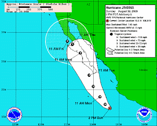
 Not much has changed in HURRICANE JIMENA over the last day except location and a 5MPH increase in wind speed. HURRICANE JIMENA is still a very dangerous HURRICANE with sustained wind speeds at 140 MPH or 220 KPH with higher gusts.
HURRICANE JIMENA is moving WNW at approx 8 MPH or 13 KPH. The slower progression of HURRICANE JIMENA, when compared to the speeds of HURRICANE DANNY or BILL, make HURRICANE JIMENA more dangerous when she hits an area as HURRICANE force winds will hang around for longer.
 HURRICANE JIMENA is expected to make a shift to the Nortwest then North North West over the next 48 hours. This PROJECTED PATH will bring HURRICANE JIMENA right up the Baja Coast into the southern tip of the California Baja Peninsula.


No comments:
Post a Comment