 The Atlantic Coast still seems to be getting a battering from the various tropical storms in the region. Tropical Storm Bill is continuing to grow with wind speads currently reaching 70 MPH and growing to Hurricane Force Winds by Monday. Tropical and Storm force winds are stil stretching out 140 Miles from the Eye of what will become Hurricane Bill 2009.
TROPICAL STORM HURRICANE BILL 2009
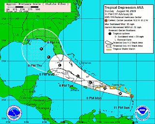
 Closer in, Hurricane Ana has calmed down substantially and is now rated as a Tropical Depression. The wind speed of TD Ana is down to 35 MPH. Although this is an improvement from a few days ago, Ana is just behind newly formed Tropical Storm Claudette. Tropical Storm Claudette is currently heading for the Alabama Florida border region with a current sustained winds speed of 50MPH with gusts reaching much higher.
On her current path, Tropical Storm Claudette is headed NNW towards the Alabama Mississippi Border. Tropical Storm Claudette is expected to bring Tropical storm force winds and cyclones as far north as Tennessee and the North Eastern corner of Arizona.
HURRICANE ANA REDUCED TO TROPICAL DEPRESSION ANA
 Tropical Storm Claudette is expected to cause a substantial amount of damage to the Florida panhandle as up to 10 inches of rain is expected along with 3 to 5 foot storm tidal swells. These swells will most likely be accompanied by Tropical Waves resulting from the winds of Tropical Depression Ana which is expected to dump up to 6 Inches of rain on the Leeward Islands, Puerto Rico and the US / British Virgin Islands.
TROPICAL STORM CLAUDETTE HEADING TOWARDS LAND
 On the Pacific Coast, Hurricane Guillermo is expected to weaken although current sustained winds in the Eye of Hurricane Guillermo reaching a maximum of 85MPH which is up from the 60 MPH they were at this morning but down from their mid day highs this afternoon.
Tropical and storm force winds are still stretching out a moderate 35 Miles from the Eye of Hurricane Guillermo, which means Hurricane Guillermo is not growing in size.
HURRICANE GUILLERMO PERSISTS BUT WEAKENS SLIGHTLY
Stay tuned to HURRICANE TRACKER and we will keep you abreast of all the developments in all the current Tropical Storms and Hurricanes in the Atlantic and Eastern Pacific regions. The current active Hurricanes and Tropical Storms for 10PM PST on Sunday August 16th 2009 are
Atlantic
TROPICAL STORM / DEPRESSION ANA 2009
TROPICAL STORM / HURRICANE BILL 2009
TROPICAL STORM CLAUDETTE 2009
Pacific
HURRICANE GUILLERMO 2009


No comments:
Post a Comment